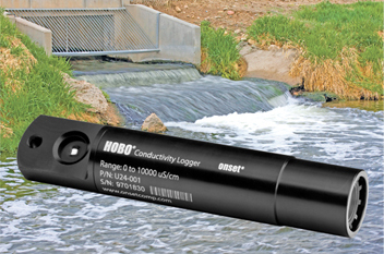
Data Loggers
The Slippery Rock Watershed Coalition, in cooperation with Stream Restoration Incorporated, is excited to announce it has received funding for the purchase of water quality data loggers (also known as sondes) for the Slippery Rock Creek Watershed through a Colcom Foundation grant! The data resulting from the use of the data loggers will provide valuable and much needed water quality information for not only monitoring degradation in the watershed by abandoned mine drainage but also for collecting baseline data prior to extensive drilling of Marcellus and Utica shale gas. Shale gas drilling has only recently begun in the watershed. Only 10 wells have been drilled within the entire 408-square mile watershed, which enables the documentation of baseline conditions. SRI has a demonstrated track record of addressing the legacy of abandoned mine drainage problems in the Commonwealth of Pennsylvania and working with industry to prevent future problems. The same partnership approach, we believe, will help us address any potential issues with the newly emerging gas industry.
 The use of conductivity dataloggers is the cheapest and most efficient method to collect water quality data on a continual basis. The Colcom grant has allowed the SRWC to permanently place a total of 12 conductivity data loggers throughout the watershed to cover the main stem and all major tributaries. The conductivity measurement can be useful in depicting the general quality of the stream. As a baseline is developed, significant changes in conductivity may indicate a discharge of pollution. In addition to the conductivity data loggers, three multi-parameter sondes will be used as mobile units to be placed for extended periods in stream segments of concern and within passive treatment systems. These multi-parameter sondes, which measure pH, ORP, turbidity, and DO, are more expensive to operate and require higher maintenance than the conductivity data loggers. This combination of sondes balances the usefulness of the additional parameters with the higher costs of operating and maintaining the devices.
Volunteers
We are very grateful for our volunteers who are downloading and maintaining the data loggers on a monthly basis. If you would like to be involved in this monitoring program, please contact Shaun Busler at (724) 776-0161 or email at [email protected].

Data
The data downloaded from the data loggers have been converted to comma delimited files (.csv), which are easily opened within spreadsheet programs such as Excel. The files have been organized below by location. The folder named Flow also contains data downloaded from the USGS gaging station near the mouth of Slippery Rock Creek and below Lake Arthur Dam on Muddy Creek.
 01 - Slippery Rock Gage (10544197)
 02 - Downstream Lake Arthur (10544194)
 03 - Upstream Lake Arthur (10544201)
 04 - Kennedy Mill (10544198)
 05 - Campground (10544196)
 06 - Wolf Creek Mouth (10544199)
 07 - Grove City (10544204)
 08 - Rock Falls (10544202)
 09 - Big Run Mouth (10423280)
 10 - South Branch Mouth (10544195)
 11 - Branchton (10544200)
 12 - Boyers (10544203)
 Blacks Creek
 Flow
Flow
